
فيشي:Map of OIC.png

حجم هاد المعاينة: 800 × 400 بكسل. أبعاد أخرى: 320 × 160 بكسل | 640 × 320 بكسل | 1,250 × 625 بكسل
لفيشي لأصلي (1,250 × 625 پيكسيل، تيساع لفيشي: 40 كيلوبايت، نوع لميديا: image/png)
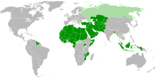
| الوصف | Members of OIC |
| التاريخ | |
| المصدر | عمل شخصي |
| لكاتب | Myrzic Cyril |
| ليسَ لهذه الصُّورة حقوق تأليفٍ ونشرٍ لأنَّها مُكوَّنة بالكامِل من معلومات عامَّة ولا تحتوي على عملٍ أَصيلٍ. ولذلك فهي في النطاق العامّّ . |
ليسطوريك د لفيشي
ورك على تاريخ/ساعة باش تشوف هاد لفيشي كيف كان كايبان ف داك لوقت
| نهار/توقيت | تصغير | الأبعاد | خدايمي | تعليق | |
|---|---|---|---|---|---|
| ديال دابا | 21:31، 2 فبراير 2018 | | 1,250 × 625 (40 كيلوبايت) | Maphobbyist | Check |
| 21:26، 2 فبراير 2018 |  | 1,250 × 625 (40 كيلوبايت) | Maphobbyist | Added borders of South Sudan which became idependent in 2011 and which is not a member of the OIC. | |
| 14:31، 27 غشت 2008 |  | 1,250 × 625 (55 كيلوبايت) | Myrzich Cyril | {{Information |Description= |Source= |Date= |Author= |Permission= |other_versions= }} | |
| 13:53، 26 ماي 2008 |  | 1,250 × 625 (55 كيلوبايت) | Myrzich Cyril | {{Information |Description= Members of OIC |Source= Собственная работа |Date= may 26, 2008 |Author= Myrzich Cyril |Permission= |other_versions= }} {{PD-ineligible}} Category:Subcontinental maps | |
| 13:31، 26 ماي 2008 |  | 1,250 × 625 (55 كيلوبايت) | Myrzich Cyril | {{Information |Description= Members of OIC |Source= Собственная работа |Date= may 26, 2008 |Author= Myrzic Cyril |Permission= |other_versions= }} {{PD-ineligible}} Category:Subcontinental maps |
تخدام لفيشي
ما كاينة حتا شي صفحة كاتخدّم هاد لفيشي
التخدام لعالمي د لفيشي
لويكيات التالية كاتخدّم هاد لفيشي:
- التخدام ف be.wikipedia.org
- التخدام ف en.wikipedia.org
- التخدام ف es.wikipedia.org
- التخدام ف fa.wikipedia.org
- التخدام ف fr.wikipedia.org
- التخدام ف he.wikipedia.org
- التخدام ف it.wikipedia.org
- التخدام ف uk.wikipedia.org