
فيشي:Volubilis map.png
حجم هاد المعاينة: 411 × 599 بكسل. أبعاد أخرى: 165 × 240 بكسل | 329 × 480 بكسل | 728 × 1,061 بكسل
لفيشي لأصلي (728 × 1,061 پيكسيل، تيساع لفيشي: 54 كيلوبايت، نوع لميديا: image/png)

|
هذه map الصورة / الصورتان باستعمال رسومات متجهية ملفات رسوميات شعاعية.
It is recommended to name the SVG file "Volubilis map.svg" - then the template Vector version available (or Vva) does not need the new image name parameter.
|
ملخص
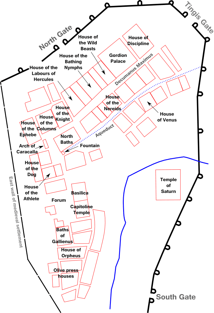
| الوصف | Plan of Volubilis |
| التاريخ | |
| المصدر |
Own work using:
|
| لكاتب | Prioryman |
| إصدارات أخرى |
|


ترخيص
أنا، صاحب حقوق التأليف والنشر لهذا العمل، أنشر هذا العمل تحت الرخص التالية:
هاد لفيشي مليصونسي ب تّرخيص لمشاع لإبداعي نسبة لعامال ل مولاه - لمشاركة ب لمساواة 3.0 لعامة
- عندك كامل الحرية:
- باش تپارطاجي – نسخ هاد لعامال و توزيعو و لبت ديالو
- ف طور لمقادة – ف لمقادة معا لخدمة
- تحت هاد الشروط:
- النسبة – خاصك تنسب لعامال ل مولاه، وتوفر ليان ديال تّرخيص، وتحدد واش تغييرات تدارو، تقدر تدير هادشي ب أي طريقة معقولة، ولاكين ماشي ب شي طريقة كاتشير بلي مول تّرخيص كيدعمك ؤلا كيدعم تّخدام د هاد لعامال.
- الترخيص بالمثل – إلا عاودتل مزج المواد أولا تحويلها أولا الاعتماد عليها، فخاصك توزع مساهماتك بموجبنفس الترخيص الأصلي أو ترخيص متوافق معه.

|
نسخ و توزيع و/أولا تعديل ديال هاد الوتيقة مسموح بشروط ترخيص ڭنو د لوتايق الحرة، لإصدار 1.2 و أي إصدار جاي كاتنشرو مؤسسة الصوفتوير الحرة؛ بلا أقسام تابتة و بلا نصوص د لغلافات لقدّامية و بلا نصوص لغلافات اللورانية. نسخة من الترخيص تم تضمينها ف القيسم المسمى GNU Free Documentation License. |
عندك الحق تختار الرخصة التي كتناسبك.
ليسطوريك د لفيشي
ورك على تاريخ/ساعة باش تشوف هاد لفيشي كيف كان كايبان ف داك لوقت
| نهار/توقيت | تصغير | الأبعاد | خدايمي | تعليق | |
|---|---|---|---|---|---|
| ديال دابا | 10:41، 28 أكتوبر 2012 | | 728 × 1,061 (54 كيلوبايت) | Prioryman | {{Information |Description=Plan of Volubilis |Source={{own}} |Date=28 October 2012 |Author= Prioryman |Permission= |other_versions= }} Category:Volubilis |
تخدام لفيشي
هاد 1 صّفحات كيخدّمو هاد لفيشي:
التخدام لعالمي د لفيشي
لويكيات التالية كاتخدّم هاد لفيشي: