فيشي:Hawaje.jpg

محتويات الصفحة غير مدعومة بلغات أخرى.
من ويكيپيديا

لفيشي لأصلي(3,600 × 2,800 پيكسيل، تيساع لفيشي: 1.16 ميجابايت، نوع لميديا: image/jpeg)

هاد لفيشي جاي من ويكيميديا كومنز و يمكن تخدّم ف پروجيات خرين. لوصف لي كاين ف صّفحة د لوصف د لفيشي مكتوب لتحت.

ملخص

الوصف
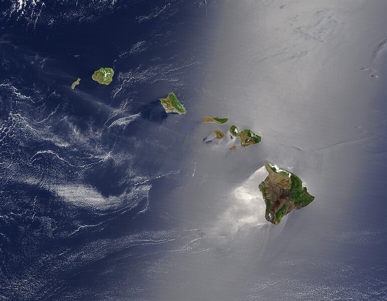
English: Satellite view of Hawaii archipellago (USA).

Original description from NASA:

"A silver swath of sunglint surrounds half of the Hawaiian islands in this true-color Terra MODIS image acquired on May 27, 2003. Sunglint reveals turbulence in the surface waters of the Pacific Ocean. If the surface of the water was as smooth as a perfect mirror, we would see the circle of the Sun as a perfect reflection. But because the surface of the water is ruffled with waves, each wave acts like a mirror and the Sun’s reflection gets softened into a broader silver swath, called the sunglint region.

"In this scene, the winds ruffling the water surface around the Hawaiian Islands create varying patterns, leaving some areas calmer than others. Southwest of Hawaii and Maui, on their leeward sides, calmer waters are indicated by brighter silver coloration. Conversely, notice how most of the vegetation on the Hawaiian Islands grows on their northeastern, or windward, sides.

"From lower right to upper left, the “Big Island” (Hawaii), Maui, Kahoolawe, Lanai, Molokai, Oahu, Kauai, and Niihau islands all make up the state of Hawaii, which lies more than 2,000 miles from any other part of the United States. The small red dot on the Big Island’s southeastern side marks a hot spot on Kilauea Volcano’s southern flank. Kilauea has been erupting almost continuously since January 1983, and is one of the world’s best studied volcanoes."
Français : Vue satellite de l'archipel d'Hawaï (États-Unis).
التاريخ
المصدر NASA. Image courtesy Jacques Descloitres, MODIS Land Rapid Response Team at NASA GSFC. (IotD Date: 2003-06-03. IotD ID: 15304)
لكاتب Jacques Descloitres
إصدارات أخرى
Modified version
هذا رسمٌ مُعَدَّلٌ رقميَّاً من النسخة الأصليَّة. التعديلات هي: cloned out and healed little red line on the big island. يُمكن الاطلاع على النسخة الأصليَّة هنا: Hawaje.jpg. المُستخدم الذي أجرى التعديلات هو: IdLoveOne.

Derivative works

أَعمالٌ مُشتقَّة مِن هذا الملفِّ:  Hawaje-NoRedLine.jpg

ترخيص

Public domain يقع هذا العمل في النِّطاق العامّ في الولايات المُتحدة الأمريكيَّة لأَنَّه عملٌ خالِصٌ من إِنتاج وكالة الفضاء الأمريكيَّة. تنصُ حقوق التَّأليف والنَّشر الخاصَّة بوكالة الفضاء الأمريكيَّة على أنَّ "أعمال الوكالة غير مَحميَّة بحقوق التَّأليف والنَّشر ما لم يُذكر خلافُ ذلك". لمزيدٍ من المعلومات انظر القالِب {{PD-USGov}} وصفحة حقوق التَّأليف والنَّشر الخاصَّة بالوكالة وصفحة سياسة الصُّور الخاصَّة بمُختبر الدَّفع النَّفَّاث.
تنبيهات:

الشروحات

أضف شرحاً من سطر واحد لما يُمثِّله هذا الملف

العناصر المصورة في هذا الملف

يُصوِّر العربية

27 ماي 2003

ليسطوريك د لفيشي

ورك على تاريخ/ساعة باش تشوف هاد لفيشي كيف كان كايبان ف داك لوقت

نهار/توقيتتصغيرالأبعادخدايميتعليق
ديال دابا19:19، 26 أكتوبر 2005التصغير ديال النسخة بتاريخ 19:19، 26 أكتوبر 20053,600 × 2,800 (1.16 ميجابايت)PalladinusHawaii Islands

ما كاينة حتا شي صفحة كاتخدّم هاد لفيشي

التخدام لعالمي د لفيشي

لويكيات التالية كاتخدّم هاد لفيشي:

ميتاداتا