
فيشي:Birkenau múzeum - panoramio (cropped).jpg

لفيشي لأصلي (2,048 × 1,357 پيكسيل، تيساع لفيشي: 875 كيلوبايت، نوع لميديا: image/jpeg)
ملخص
| الوصف |
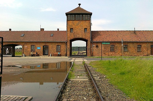
The gatehouse of Auschwitz II, also known as Auschwitz II-Birkenau, a Nazi German extermination camp in occupied Poland during the Holocaust. The building is preserved by the Auschwitz-Birkenau museum. This image shows the tracks from outside the camp leading through the gate to the third unloading ramp and the gas chambers. The first ramp was built in 1940 next to Auschwitz I, the main camp. The second ramp, the "Alte Judenrampe", was built in the Oświęcim freight station between Auschwitz I and Auschwitz II, and was used to receive mass transports of Jews and others until May 1944, when the third ramp was completed: "The third ramp was built from 1943 inside the Birkenau camp, and went into operation in May 1944 in connection with the anticipated arrival of transports of Hungarian Jews. The railroad spur along this ramp ran as far as gas chambers and crematoria II and III. Aside from the 430 thousand Hungarian Jews, 67 thousand Jews from the Łódź ghetto and some of the transports from the ghetto in Terezin and from Slovakia were unloaded at this ramp. From this point on, mass selections of Jews took place inside the camp, before the eyes of thousands of prisoners. Transports of Poles from Warsaw during the Uprising there, sent to Auschwitz by way of the transit camp in Pruszków, were also unloaded here" (Auschwitz-Birkenaum museum). |
||
| التاريخ | التقطت في 1 يونيو 2011 | ||
| المصدر | https://web.archive.org/web/20161023024548/http://www.panoramio.com/photo/53636819 | ||
| لكاتب | pzk net | ||
| الترخيص (معاودة د تخدام هاد لفيشي) |
هذا الملف مُرخص تحت رخصة المشاع المبدع نسبة المصنف إلى مؤلفه 3.0 العامة النسبة: pzk net
|
||
| إصدارات أخرى | |||
| Tags (from Panoramio photo page) | Brzezinka, Birkenau múzeum |

.jpg)
| موقع الكاميرا | | هذه وغيرها من الصور في مواقعها على: خريطة الشارع المفتوحة |
|---|
.jpg¶ms=050.034660_N_0019.181316_E_globe:Earth_type:camera_source:Panoramio_&language=ary)
ليسطوريك د لفيشي
ورك على تاريخ/ساعة باش تشوف هاد لفيشي كيف كان كايبان ف داك لوقت
| نهار/توقيت | تصغير | الأبعاد | خدايمي | تعليق | |
|---|---|---|---|---|---|
| ديال دابا | 20:44، 12 أكتوبر 2019 | | 2,048 × 1,357 (875 كيلوبايت) | SlimVirgin | == {{int:filedesc}} == {{Information |description=Birkenau múzeum |date={{Taken on|2011-06-01}} |source=https://web.archive.org/web/20161023024548/http://www.panoramio.com/photo/53636819 |author=[https://web.archive.org/web/20161023024551/http://www.panoramio.com/user/5960581?with_photo_id=53636819 pzk net] |permission={{cc-by-3.0|pzk net}} {{Panoramioreview|Panoramio_upload_bot|2016-11-25}} |other_versions={{extracted from|File:Birkenau múzeum - panoramio.jpg}} |other_fields={{Information fi... |
تخدام لفيشي
هاد 1 صّفحات كيخدّمو هاد لفيشي:
التخدام لعالمي د لفيشي
لويكيات التالية كاتخدّم هاد لفيشي:
- التخدام ف ast.wikipedia.org
- التخدام ف ban.wikipedia.org
- التخدام ف bn.wikipedia.org
- التخدام ف ckb.wikipedia.org
- التخدام ف cy.wikipedia.org
- التخدام ف en.wikipedia.org
- التخدام ف en.wikiquote.org
- التخدام ف en.wikivoyage.org
- التخدام ف eu.wikipedia.org
- التخدام ف fa.wikipedia.org
- التخدام ف ga.wikipedia.org
- التخدام ف gl.wikipedia.org
- التخدام ف he.wikipedia.org
- التخدام ف he.wikivoyage.org
- التخدام ف hy.wikipedia.org
- التخدام ف it.wikipedia.org
- التخدام ف it.wikibooks.org
- التخدام ف it.wikivoyage.org
- التخدام ف ko.wikipedia.org
- التخدام ف lb.wikipedia.org
- التخدام ف lt.wikipedia.org
- التخدام ف pl.wikipedia.org
- التخدام ف pt.wikipedia.org
- التخدام ف ru.wikipedia.org
- التخدام ف ru.wikinews.org
- التخدام ف sk.wikipedia.org
- التخدام ف sl.wikipedia.org
- التخدام ف th.wikipedia.org
- التخدام ف uk.wikipedia.org
- التخدام ف uk.wikivoyage.org
- التخدام ف uz.wikipedia.org
- التخدام ف vec.wikipedia.org
- التخدام ف www.wikidata.org
شوف تّخدام لأعم ديال هاد لفيشي.
.jpg)
.jpg)